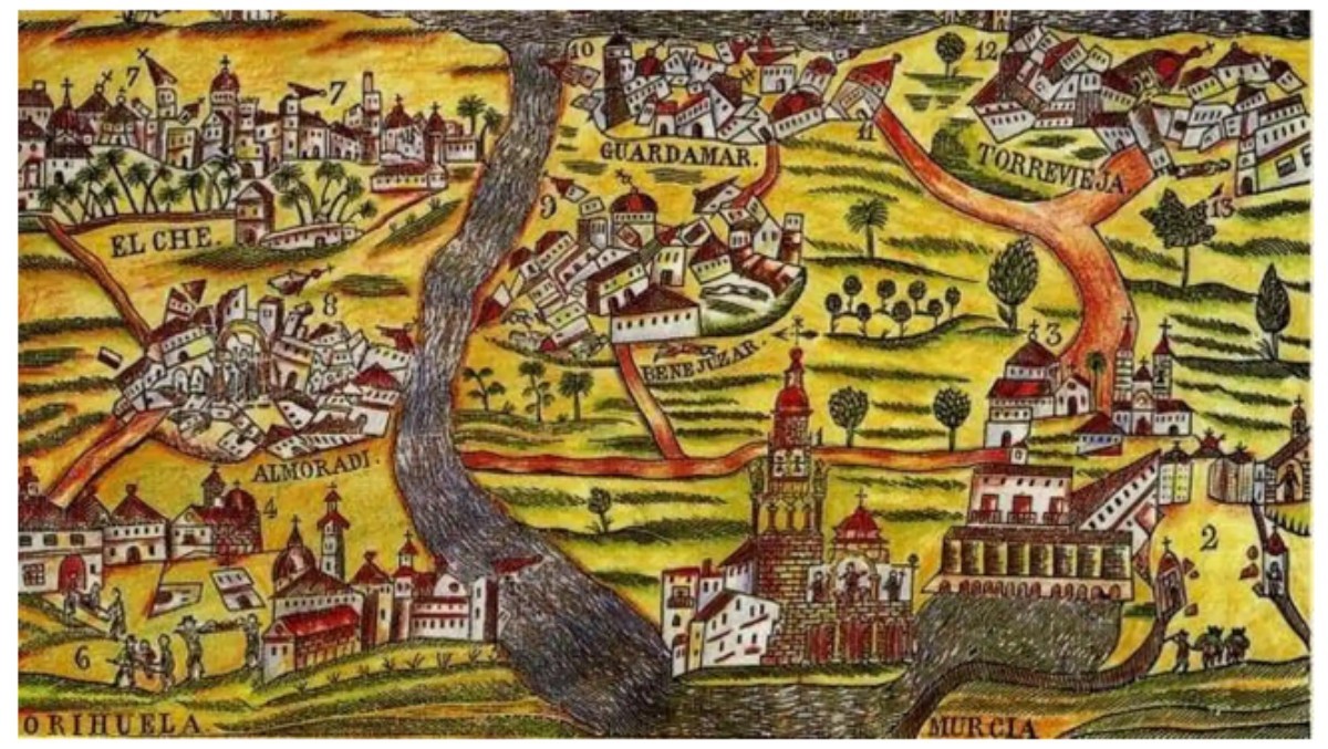
El 21 de marzo de hace 196 años, uno de los tres terremotos más importantes de los registrados en España asoló Torrevieja, la Costa de Orihuela y otros tres municipios de la Vega Baja: Almoradí, Benejúzar y Guardamar. Los pueblos fueron completamente reconstruidos. La tragedia dejó casi 400 muertos y centenares de heridos.
El Instituto Geográfico Nacional solo tiene documentados en España otros dos terremotos con el mismo nivel de destrucción. El que afecto el 1 de noviembre de 1755 al Cabo San Vicente, que produjo un tsunami de casi 15 metros de altura y el que se registró el 25 de diciembre de 1885 en Arenas del Rey (Granada), con 4.400 edificios destruidos y más de 13.000 dañados.
¿Qué sucedió en la Vega Baja el 21 de marzo de 1829?
Según las crónicas dé de la época, el periodo comprendido entre 1820 y 1830 fue uno de los de mayor actividad sísmica en la provincia de Alicante. Esta intensidad fue significativa entre el 13 de septiembre de 1828 y el 21 de marzo de 1929, periodo durante el que se registraron 200 temblores.
En este ultimo día fue cuando la tierra tembló con mayor intensidad. Sobre las seis de la tarde del 21 de marzo se registró una terremoto de magnitud 6,6 en la escala Richter. El epicentro estuvo en los núcleos de Benejúzar, Rojales y Torrevieja. La catástrofe dejó casi 400 muertos y centenares de heridos, casi 3.000 viviendas destruidas y otras 3.000 dañadas. Se derrumbaron los puentes que cruzaban el río Segura en Almoradí, Benejúzar, Dolores y Guardamar.
Además de a los municipios afectados en el epicentro, que sufrieron una total destrucción, el terremoto afectó a las poblaciones de Almoradí, Algorfa, Rafal, Torrelamata, Daya Vieja, Guardamar, Dolores, Redován, San Fulgencio y San Miguel de Salinas. La población con mayor numero de fallecidos fue Almoradí. Es tradición en este municipio que cada año sus habitantes saquen a la calle a San Emigdio, Santo Patrón de los terremotos, para rezar a todas las víctimas.
Puede ocurrir otra vez, pero el riesgo es bajo, esta monitorizado y se descarta un tsunami por la configuración de la plataforma marina.
Aunque los estudios acreditan dos zonas de la provincia de Alicante, la de l’Alacantí y las comarcas del sur, susceptibles de tener terremotos de intensidad 6 en la escala de Ritcher, el Departamento de Ingeniería Sísmica y Geodesia de la Universidad Politécnica de Valencia cree que la posibilidad de que se reproduzca un seísmo similar en la Comunidad Valenciana es moderada o baja.
Además, el territorio está monitorizado con sismógrafos y acelerógrafos. Se sabe donde pueden ocurrir, pero no cuando por lo que el control para su predicción es fundamental para avisar a la población.
Lo que descartan los expertos es que la costa valenciana pueda sufrir un tsunami. La magnitud de un terremoto nunca va alcanzar un sismo superior a 6 o 7 grados, y al tener una plataforma continental muy desarrollada con una profundidad pequeña de 200 o 300 metros impide que se generen olas grandes y destructivas.

196 years after the great earthquake that devastated Torrevieja and Orihuela
On 21st March 196 years ago, one of the three most important earthquakes ever recorded in Spain devastated Torrevieja, the Orihuela Costa and three other municipalities of the Vega Baja: Almoradí, Benejúzar and Guardamar. The towns were completely rebuilt. The tragedy left almost 400 dead and hundreds injured.
The National Geographic Institute has documented only two other earthquakes in Spain with the same level of destruction. The one that affected Cape San Vicente on 1 November 1755, which produced a tsunami almost 15 metres high, and the one that occurred on 25 December 1885 in Arenas del Rey (Granada), with 4,400 buildings destroyed and more than 13,000 damaged.
What happened in the Vega Baja on 21 March 1829?
According to the chronicles of the time, the period between 1820 and 1830 was one of the most active seismic periods in the province of Alicante. This intensity was significant between 13 September 1828 and 21 March 1929, a period during which 200 tremors were recorded.
It was on the latter day that the earth shook with the greatest intensity. At around six o’clock in the evening on 21 March, an earthquake of magnitude 6.6 on the Richter scale was recorded. The epicentre was in the towns of Benejúzar, Rojales and Torrevieja. The catastrophe left almost 400 dead and hundreds injured, almost 3,000 houses destroyed and another 3,000 damaged. Bridges across the Segura river collapsed in Almoradí, Benejúzar, Dolores and Guardamar.
In addition to the municipalities affected at the epicentre, which suffered total destruction, the earthquake affected the towns of Almoradí, Algorfa, Rafal, Torrelamata, Daya Vieja, Guardamar, Dolores, Redován, San Fulgencio and San Miguel de Salinas. The town with the highest number of deaths was Almoradí. It is a tradition in this municipality that every year the inhabitants take St. Emigdio, the Patron Saint of earthquakes, to the streets to pray to all the victims.
It could happen again, but the risk is low, it is monitored and a tsunami is ruled out due to the configuration of the marine platform.
Although studies show that two areas in the province of Alicante, the Alacantí and the southern regions, are susceptible to earthquakes of intensity 6 on the Ritcher scale, the Department of Seismic Engineering and Geodesy of the Polytechnic University of Valencia believes that the possibility of a similar earthquake occurring in the Valencian Community is moderate or low.
Moreover, the territory is monitored with seismographs and accelerographs. It is known where they can occur, but not when, which is why monitoring for their prediction is essential to warn the population.
What the experts rule out is that the Valencian coast could suffer a tsunami. The magnitude of an earthquake will never reach an earthquake of more than 6 or 7 degrees, and having a highly developed continental shelf with a shallow depth of 200 or 300 metres prevents the generation of large, destructive waves.
Translated with DeepL.com (free version)